Woolacombe to Croyde and beyond

IMG_0417

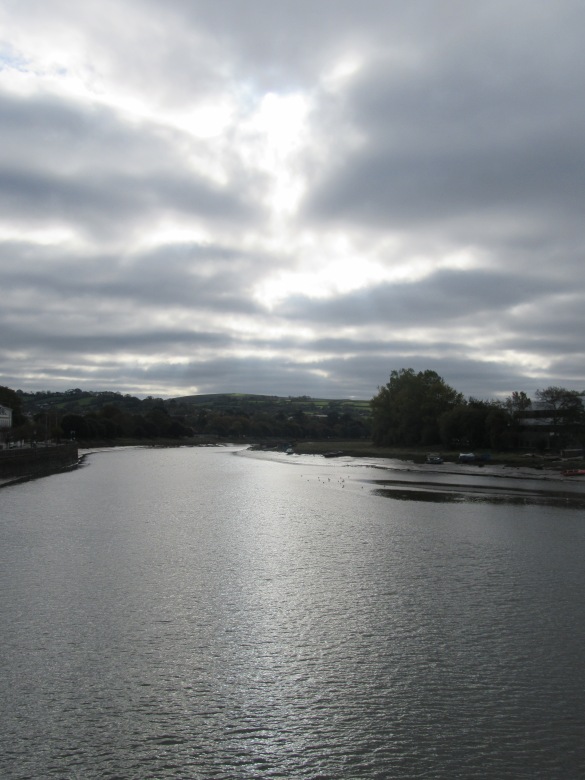
Bolstered by our success of doing a “half day” walk in a day using public transport from Exeter, 2 days later we came back to do the next one, pausing to take in the sky from Barnstaple bridge on our way from the train station to the bus station.

IMG_0424IMG_0423

The start was a bit shakey. As we came into the edge of Woolacombe on the bus, we saw a sign for the SWCP Woolacombe via Mortehoe. It wasn’t the way we’d gone, and The Boy was worried we’d gone  wrong, but I quickly explained it was an alternative route and we’d definitely gone the right way last time. Once in Woolacombe we had 15 mins to kill before the chip shop opened and we went and admired the view of the start of the days route along Woolacombe Beach towards Baggy Point, said hi to a clearly visible Lundy, and double checked the signs for the path.  He once again became convinced we’d walked the wrong way, (across the grass and through the car park next to the pavement, rather than along it). He insisted we started to retrace our steps but luckily we came across some random strangers out walking and after a few hints dropped from me they confirmed that we’d definitely come the right way last time and we were allowed to go and buy some lunch. Phew.

Finally, with chips in hand it was time to start the walk proper. Here there was another problem, the guide book suggested not one but three routes (including the beach, which I rather fancied as it was low tide). However my walking companion decided that the route through the dunes was the official one and so that’s the way we went, mere fleeting views of the sea be damned.

Turns out that my brainwave of chips whilst strolling was not so good when my son didn’t spot a huge hole (dug by a dog maybe) and fell dropping chips everywhere.  However his decision was pretty good as I actually found walking through the dunes interesting, even if I couldn’t see much of the sea.

It was still quite sandy and slow going, but before too long we were nearing the far end of the (very long) beach and took a turn up and onto a track, so heading up to the ridge of that heads out to Baggy Point. We got a good view down to Puttsborough sands and could see back the way we’d come to Morte Pt and beyond, which we presumed was Bull Pt.

It wasn’t far onto Baggy Point (even with my companion insisting on going through the dog gates) where we found a mysterious post that we later discovered was a coast guard look out back in the day. Looking back we because increasingly convinced that what we originally thought was Bull Point was in fact Wales, which seemed odd, as the day was greyer than 2 days before so it felt like we couldn’t see as far. We could definitely see Lundy out in the bay and we could also now see Croyde, the mouth of the, Barnstaple/Bideford estury and on round the bay to Hartland Pt and started heading inland.

Then disaster, we met up with the coast path. Turns out we should have gone walked towards the edge more at baggy pt and found the path that comes lower around the headland. I tried to sit on the bench and have some peace and quiet and send the boy back on his own (there were loads of people and families about walking to Baggy pt from Croyde), but he texted me that I had to come see the spectacular view, and yes, when you went the right way there was a nice view of some rocks.

We picked up some postcards in the national trust car park and had a pit stop at a cafe, before going on into Croyde and over the beach (officially, phew).

We were making good time, so decided to go round the next headland, passing some specutacular looking rocks and a gun post, which the boy went to explore whilst I spoke to a local who confirmed that we could indeed see the Gower Peninsular today and also Lundy, although he said it would “trolley off” later doubtless.

We passed what we think was the old coastguard building, which appeared to be getting done up, and then nearly missed the path as you had to cross the main road and then double back on yourself slightly to get onto it. It was a few metres in from the road and several up as the hillside was steep. The views were great but we didn’t have time to stop as the next bus was due soon. We made it to the Saunton Hotel with a couple of minutes to spare before the bus and felt very smug with ourselves that we’d done a bit extra than planned.

This time we did see the sunset in Barnstaple (but no photo’s) and got the train home an hour earlier than the previous trip, much more civilised!

The path between Croyde and Westwood Ho! is never very far from the 21 bus route, which also goes to the station in Barnstaple, so we hope to get in a few more day trips and finish our first “weeks” walking.

Return of the SWCP

Back in July I was so smug with our progress along the South West Coast Path, but the timings didn’t work out in August and then Septmeber was busy and we got no furhter. However, we started to get back on track (literally as well as figuritively) during the October half term.

First up, Ilfracombe to Woolacombe, and this time with No Support Crew. Rather we utilised trains and buses and did the whole thing in a day, getting back home about 13 hours after we left.

IMG_0228[1].JPG

We started round the back of the two upturned flower pots that are the Landmark Theatre, but not until after we popped in to use the facilities and I spied this rather amazing tapestry on the wall.

Pretty much straight away we were walking alongside some pretty impressive geology and we realised just how big Ilfracombe was with it all spread out in the view alongside this rather ornate house

After the path took a dogleg through what felt like someones garden, we were soon out of Ilfracombe. I was immediately struck by the contrast between the now brown ferns and those first shoots ready to unfurl on our first walk back in May. We preferred the cooler temperatures to walk in to some of the heat we had to endure ealier in the year too! Sadly we didn’t have time to go and investigate the steps we saw cut into the cliff, I think they probably lead down tot he old lime kiln we saw mention of on an information board.

IMG_0243[1].JPG

Apparently the hole in the rock that The Boy is clinging onto was made by a giants fingernail as he scrambled up the cliff, recreated here by the storyteller.

IMG_0246[1]

Yup, that looks like the coast path alright.

They sure have some impressive walls in this part of Devon, both new built and long overgrown,  as well as patched up.

As we approached this rather ornate sign from the wrong side we mused on what it said. I couldn’t resist standing a few feet off the path to get a good shot of it and the coast we’d just come from in the background.

Soon after the sign we stopped to watch what we think was a kestrel hovering above a headgerow and then before we knew it we were descening into Lee, passing this rather lovely looking tiny house, complete with what apeared to be a bicycle having a cup of coffee whilst enjoying the view inside!

We detoured slightly from the path in Lee, heading into the village to have a bite to eat in the Grampus Inn, which took us past a beautiful gate with a gate watching a mouse on an apple, and another at the same property with an owl watching another little rodent. We spoke to a friendly woman in the garden after lunch who told us that they were both carved by her husband, but we forgot to ask about the Orca or Grampus on that was nearby.


After food, it was back to the bay in Lee with its impressive rocks, past a door with the strangest shaped hinges I have ever seen, and on to the more strenuous second half of the walk. We weren’t sure what the National Trust Half Way sign was showing half way for!

After such a long break and without the support crew around, I was a little concerned how strenous it would be, but we managed just fine, in fact The Boy kept sprinting up steps when we came across them!

It didn’t seem long before we reached Bull Point, which the start of turning the coast turning  the corner and us heading south not east. We could just make out Wales in the distance and waved goodbye, then we admired a HUGE mushroom near the lighthouse, where the assistant was mowing the lawn.

The stretch to Morte Point also passed fairly easily, despite more ups and downs, maybe finding a box of ducks disguised by a bit of log helped morale!

Morte point was very impressive and pointy and there seemed to be a lot of people walking to here and back from Woolacombe.

From this point the coast path is definitely going south and it wasn’t far on to Woolacombe.  We admired the beach from up high, but decided to use up the remainder of our time before the bus having a little snack in a cafe instead.

IMG_0416[1].JPG

Whilst The Boy was disappointed that we missed the sunset (we were waiting for the burrito’s we’d ordered to take to the station and eat on the train back), Barnstaple looked very pretty by moonlight when viewed from the bridge and I was just happy that all the public transport times I’d found online turned out to work in real life!

The walking continues.

So now that I can pretend I still do sewing from time to time, back to the walking….

IMG_0064

Actually, this wasn’t walking, this was the view for our Friday night fish and chips on the beach in Combe Martin, just metres from the Coast Path and not much further from our camp site.


And a pretty impressive view it was too!


A nice relaxing start to our weekend.


Saturday was a tad more taxing. We all drove round to Hunters Inn, then the Support Crew (including dog) walked the fairly flat path to Heddons Mouth (I’m jealous not to have made it there myself, only having seen it from on high, its a pretty looking walk through the valley bottom to a small beach with dramatic scenery all around) whilst the Boy and I started the days walk by ascending the steep side of the cleave, luckily there was shade on the way up and the view at the top from Peter Rock was worth it.  Oh, and we had fresh legs too, which helped, having broken up the suggested Lynton to Combe Martin walk.


Next came a flattish section (by coast path standards) along the side of the cliff with nice views (although Wales was just a haze) and we finally spotted one of the crickets we keep hearing, or maybe it was a grasshopper.


After following the still flattish path inland a bit we then had a steep descent into Sherrycoombe (which had a disappointing lack of sherry), we had a pit stop in the shade of a tree and I cooled my feet in the stream and then it was up the other side (further up but less steep than our way down) and we kept on going until we reached Great Hangman, the highest point on the whole of the South West Coast Path, where The Boy posed on the cairn on top and a previous walker had left a declaration of love nearby.


Another flattish section, with evidence of sheep (the wool they’d left hanging on a scratching tree reminded me of prayer flags) to Little Hangman, where we took a small steep diversion to the top, which indeed had better views than Great Hangman as we’d been told, letting us see down into Coombe Martin Bay.


Then we just had to make our way down into Coombe Martin itself, where we met up with the Support Crew and had another meal on the beach, this time cooked by Long Suffering Husband. At this point the signpost said* that we had come 35 miles from Minehead and The Boy worked out this meant we were over 1/20 of the way.


Sunday was a first for us, two days walking in a row. We left the support crew and set off up the hill out of Coombe Martin with a view across the bay back towards Little Hangman, passing some impressive eagle gateposts on our way. There was a short section on the main road, before getting on to what some locals told us used to be the main road, before some of it was eroded, which apparently included a section of cobbles from the 1800’s. The bus shelter turned Tourist Information Point that the guidebook mentioned was no longer there, apparently it was falling off the cliff, and instead the base is now a viewing platform. Then the path passed through a campsite and we were walking between tents, which was a little odd.


Soon we were at Watermouth, the tide was too far in for us to cut across the foreshore, but we had a quick look at the boats and overheard some fisherman discussing where the shoals were (or rather weren’t) and saw a nice cafe, although it was too soon in the day for us to stop. The path technically is alongside the road here, but with such a lovely hedge shielding it from view we didn’t really mind.


The next headland, Widmouth Head, provided a lovely view back across Watermouth to Combe Martin Bay, Little and Great Hangman and beyond and The Boy decided to make a sketch.

IMG_0227

Proud Parent Moment.


Meanwhile I watched the boats in Samson’s Bay and beyond, then it was onto and around Rillage Point with it’s cave and more impressive views of Hele Bay and beyond. I think that might be a Giant Hogweed we went past, I was careful we didn’t touch it.


There was a small stretch along the road again as we descended into Hele, where we speculated on why some of the barrier had cable reinforcing it and not others, decided that the Viewpoint With Car Park was no where near as good as the views from the path, and were heartened when the Support Crew happened to drive past waving and cheering, you can just make them out in the distance if know what you’re looking for.


We took advantage of the facilities in Hele to buy cold drinks to help us up the last hill between us and Ilfracombe, Beacon Point, once again shade on the steep way up helped and we were rewarded with views from the top down towards Ilfracombe.


Then it was a pleasant descent down into the town, where we reunited with the rest of the family, had lunch, wondered on how an statue of a pregnant woman rendered in anatomical text book detail can represent truth, walked round Capstone point (sans red petticoats) and had a rest on the beach / clamber on the rocks before heading back home.

So, Minehead to Ilfracombe. Starting to feel like we’re getting somewhere!  And at 3 1/2 days worth of suggested walks we’re half way through Week 1.


*The signposts have proven somewhat erratic at times, occasionally the distance you have walked decreases from one signpost to the next, and they doesn’t exactly match up with either the website or guide book distances either.

Camping, Dancing and Walking

Sewing, eh, what’s that.  Been a bit too busy for that round these parts.  Not to mention too hot (those of us with pale “Celtish” skin and redish hair don’t do well in the unusal prolonged heat wave we’ve been having).

IMG_0591.JPG

One of the things that’s been keeping me busy is Morris, last weekend we were at a festival, this weekend at Borderline’s 10th Anniversary celebrations and as a side we were so short numbered that yours truly had to dance a lot (not in itself a bad thing, just unusual).   Here are some Otters joining in with a Bloodstone Dance.

IMG_0588.JPG

Now, the weekend involved camping back at Caffyn’s Farm, near Lynton, where we stayed after our Porlock to Lynmouth walk, which was more than a little convenient for our South West Coast Path purposes. The Otters made full use of the permission to have fires on this site and we used the new Dutch Oven to make chilli and the lid to make morning pancakes, all on an open fire.

IMG_0600

The Boy and I declined the coach back to the campsite from Lynmouth , instead electing to walk, as taking the Funicular Railway up the hill was declared cheating, so we took the path that zig zagged around the rails instead (plus we had had a ride downhill earlier in the day).

IMG_0601.JPG

Once at the top in Lynton we had completed the suggested walk from last time and had a view over to Countisbury head and the terrifying path along the exposed headland.

IMG_0602.JPG

Then we walked around the headland to the Valley of the Rocks this bit of the path was really quite impressive.  The Boy was taken with this natural rocky “throne” and also some rather noisy crickets that we could hear but not see. The Valley of the Rocks in a Honey Spot for Tourists and has plenty of parking and this section of the path was tarmacked, although I wonder how many of them make it very far from the carpark, the view inside the valley itself (which is unusual in that it runs parallel to the coast) is less spectacular.

Then we walked along the coast path as far as Lee Abbey, before leaving it for a path heading inland that took us back to our campsite.

The next day we retraced our steps back to the path and walked on as far as Heddons Mouth, about a third of the way to Coombe Martin, which is the end of the next suggested days walk and the one I was feeling most apprehensive about as it’s clearly the most arduous walk we plan to do this year, so I was really glad to get a headstart on this section. Although I suspect we have done the flatter third of that stretch and the real strenuous stuff  for next time.

No photo’s, as my camera battery was dead, but it really was a lovely stretch of coast. A fair section lot of the walk is along the single track road but we weren’t bothered much by traffic and there was a fair bit of woodland to walk through too around Woody Bay and we found a four ways signpost pointing to Iceland, Russia, New Zealand and America! Then the last stretch pretty much followed a contour around the next bit of headland to the cliff above Heddons Mouth and descend down inland to the valley floor. We left the path again at this point and walked along the wide path alongside the river to the Hunters Inn Pub where we met up with the Morris sides who had conveniently convened there for lunch and a last little dance of the weekend. We were a bit damp as we turned up, having had our first rain on a walk, a gentle drizzle on the cliff top that turned into a torrential downpour on the last stretch through the trees to the pub, but luckily LSH had driven around in the van and spare clothes were on hand.

After lunch, I drove a sleepy Girl and Hound back home whilst LSH and the Boy cadged a lift on to some more Morris Dancing with the rest of the Otters who hadn’t been able to make it to the north coast.

Returning to Devon

Part two of our South West Coast Path Walk started with a drive up the Exe Valley to Exmoor and this time we drove over the top and looked at the views, over to the Quantocks, the Minehead headland where we started last time and the flat plain of Porlock where we ended our previous walk across the saltmarsh.

We camped right in the centre of Porlock at a nice little sight with sea views and went for a little explore that evening and tried out the local park.

The support crew gave us a lift to Porlock Weir in the morning and it looked quite different with the tide in, but we were soon on our way.

Our approach scared some lambs from the path, back under the fence to their mothers and we saw the first of many foxgloves on our way to the Toll House, where vehicles can pay for the privilege of getting to Lynmouth without having to negotiate the infamous Porlock Hill. We however, took the right hand option and the path to Culborne Church and beyond.

Whilst the path was steep in places, on the whole this stretch of the path felt flatter than last time and was mainly through woodland, with the occasional glimpse at the sea.

The path passes so close to Culborne Church that it would be rude not to poke your head inside. Especially when you know it’s going to be your last look at civilisation for a while.

We took the more coastal route and it was reasonably flat, with the odd little steep detour round a landslide. The coombes on this stretch were less dramatic, and therefore easier to navigate, we could generally hear the little streams and waterfalls before we could see them. There were still the occasional glimpses of the coast and at one The Boy even spotted a rainbow down below us.

We crossed the county line back into Devon from Somerset just before the little shrine at Sisters Fountain (where a stream emerges from the hillside), and found the boars head gateposts the guidebook mentions with ease. Soon after we hoped to have lunch with a view of the sea as the map showed we would be out of the woods, however, the rhodedendrums that have spread along this part of the coast continued to hamper our view, rendering several old benches built into the wall less tempting than they presumably were when built.

We eventually got our view and a lunch spot, and the boy celebrated by sending his Dad a text from my phone (what a great spot for a technology lesson, he’s still getting used to predictive text as he doesn’t have his own phone yet) and then it started raining! Never mind, we were soon back in amongst the trees and yet more rhodedendrums.

The rain had cleared when we finally emerged from the trees just before Foreland Point, and we decided to take a slight detour round the headland to see the lighthouse. The views there were spectacular, but the path from the lighthouse round the far side of the headland was little more than a goat track on a steep hillside and had a couple of warning signs to boot. It felt far too risky to me, so we retraced our steps back and went over the top of the headland instead.

Finally we could see Lynmouth and it was only two miles away, nearly there and all downhill, this is the easy bit I thought.

But it was pretty windy on that headland and we were basically walking along a narrow path along a steep cliff with nothing to break our fall if we slipped. I was pretty terrified most of the way down until we reached the wooded lower slopes.

The support crew were patiently waiting for us we came out onto the beach, having already scoped out the toilets and a likely looking fish and chip shop, and we all had tea there before heading back to the van, which was parked near a slightly depressing sign informing us that we had come 20 miles from Minehead and still had 609 to go to Poole. We didn’t even actually complete the suggested days walk, which was due to end up the hill in Lynton.

It was a slightly frazzled trip to the next campsite, in trying to avoid some of the steepest hills but still find a cashpoint in the middle of nowhere, we somehow ended up going round in circles for a while, and backseat navigators with Asperger’s are not the most calming people to have around in such situations, but we got there in the end and the kids even got to toast marshmallows. The real treat though, was the breakfast fritatta that LSH made the next morning in his new Dutch Oven, which was The Best Camping Breakfast Ever.

Starting a New Kind of Project

I have had an idea for a new kind of project brewing for a while and last week I made a snap decision to make a start. The Boy decided to get involved, I roped in LSH to help and The Girl and The Dog got dragged along for the ride.

IMG_0013

So What Is This Project?  Walking the South West Coast Path, which goes from Minehead in Somerset, along the North Devon and Cornwall Coasts, back along the South Cornwall and South Devon coasts, then along the Dorset coast to South Haven Point, a whopping 630 miles in total. There are suggested ways of breaking this into 30, 46 and 82 day walks, but we’re starting off working from the standard 52 day list, although we won’t be tackling it in 8 weeks solid, I think a weeks worth of walks a year for 8 consecutive years will be challenging enough for us.

I’ve been musing on doing this for while, from when The Boy and I walked a couple of sections previously, and when someone gave me Walking Away as a present, and my brothers tales of walking the John Muir Way near his home in Scotland, but in the end, it was the fact that we had a bank holiday weekend coming up with nothing planned that spurred me into action.

After sorting and packing the camper van, we had brunch on Sunday and then drove from up the Exe Valley, through Tiverton and on through Exmoor to Minehead. When the iconic headland came into view LSH told The Boy “You’ll be walking up that tomorrow” and I thought “Eek, what have I done”.

We’d booked in a nice little campsite that allowed vans and kids and dogs and after settling in and making daisy chains we walked into Minehead to explore. I didn’t think much of the town itself, all Poundland style shops and not much else, but the kids had fun on the beach while I took The Dog (who was Not Allowed on the beach, it being high season now) past the harbour to explore the grassland at the start of the coast path. Eventually the rest of the family caught us up and then we all walked back to the campsite following a stream through some parks most of the way, ate and got an early night (well, for adults at least, later than usual for the Kids but there is no point trying to get them to sleep before dark on a campsite).

In the morning we had a cooked breakfast and packed up the van in record time and then drove down to have the obligatory photo taken by the statue that marks the beginning/end of the walk. Then LSH drove the van 2 minutes to the carpark whilst the rest of us walked. I’d been reading the everyone the initial chapters of Walking Away at the campsite so The Girl made us a sign to match the one Simon Armitage got. And then we all walked across the meadow and into the trees. But as the path turned steep, The Girl refused to go any further (despite their being a perfectly nice circular walk around the headland that starts on the SWCP) and it was time to say goodbyes.

The walk up the headland was steep, but the lovely woodland provided welcome shade from the heatwave we were having. Going was slow as I stopped to take photo’s and The Boy stopped to look at boats through his binoculars and kept wanting to look at the map. We were walking just as the ferns were getting ready to unfurl and I thought they looked like alien lifeforms.

We also found a “cave of bees” (several bumble bee’s going in and out of the holes in the rock, moving too fast for me to photograph), and puzzled over the many short branches coming diagonally of the track leading straight to the steep cliff.

Once up the top onto Exmoor, we chose the “rugged” alternative that hugs the coast and gave us spectacular views down the cliff to the see where we could see the sea mist / clouds below us (there was a bit of a debate on that one) and a shoal of fish moving around and breaking the surface. There were several coombes (steep sided valleys) to cross and a long straightish stretch where it was hard to tell how far along we were and The Boy starting worrying aloud that we had fallen onto an Infinite Path and would have to chose between eventually starving to death or plummiting to our doom off the cliffs when despair overtook us. There were lots of pretty flowers for me to take photo’s of, including some blue bells, which I associate more with woodlands than clifftops.

We did make it to the other side of Exmoor though and then down a really steep slope that I found very unpleasant to negotiate and a short detour to Hurlstone Point, where we finished our lunch and The Boy expolored the ruin, clambered on the rocks and saw a lizard a bit like this. Then after rejoining the path there was a short stretch through the lovely shade of the woods and along the river to Bossington (stopping to try out the tyre swing obviously) where there was a carpark with a  toilet, bliss!

We bought some apple juice from a farmhouse guarded by a large owl sculputre, then walked through the slightly eerie saltmarsh which was previously farmland but there is a managed retreat happening after a big breach of the natural shingle ridge that protected the farmland from the sea. The dead trees reminded me of the famous Salvadore Dali painting of Swans reflecting Elephants.

Thanks to the wonders of modern technology the Support Team came to meet us and walked the last bit of the saltmarsh and across the shingles to Porlock Wier with us, where we celebrated with icecreams. Then a very tired family set off for home, with a short stop for sustenance on the way.

So, 8.9 miles done, I guess that leaves 621.1 to go.